Toyota is using satellite imagery to create maps for self-driving cars.
Toyota researchers have developed a method to create detailed maps for driving self-driving cars using satellite imagery.
Researchers at Toyota Research Institute Advanced Development (TRI-AD), which is responsible for developing Toyota's self-driving technology, used camera data and satellite imagery from existing vehicles to create maps.
In addition, a method was developed to transfer map data to a cloud platform created by mapping companies such as TomTom and HERE, allowing the data to be collected in near real time and modified as needed.
To test the technology, researchers created maps of parts of Tokyo and six cities around the world with an accuracy of 25 centimeters. According to Toyota, all of these maps were found to be suitable for driving self-driving cars.
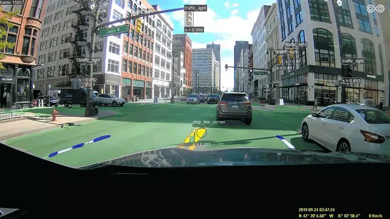
Satellite imagery was provided by Maxa Technologies, a space technology company, and on-board camera information was provided by Carmera, which uses crowdsourced dashcam information to create highly detailed maps. Dashboard cameras are used to identify basic road features such as lane markings, traffic lights, and traffic signals.
Currently, this technology is only in the proof-of-concept stage, but if it proves to be feasible, it could accelerate the expansion of map coverage while reducing costs.
"We are another step closer to a future where automated driving becomes a safer and more affordable technology for everyone," said Mandali Qureshi, vice president of automated driving and mapping strategy at TRI-AD. We will continue to work with our partners to further improve accuracy."
Toyota plans to offer the first vehicles with automated driving features later this year. The technology will be available on Lexus models, possibly only with the highway assist feature. Toyota also plans to demonstrate more advanced self-driving cars at the 2020 Tokyo Olympics this summer.
